Showing posts with label Walking in Girona town. Show all posts

Girona Modernist Route - Masó

This is a very enjoyable little stroll around the centre of Girona....looking up. It's a route hinted at on the Casa Masó website, but which they couldn't be bothered to explain properly, that or they are very reluctant to give out information without obliging you to pay a guide. Even if you're not into architecture, it's a relaxing way of seeing the town. I am devoting my blogging life to exposing the secrets of Girona. 
Here is a list of the buildings (there are more, but maybe not so interesting to look at), built by Masó in the Modernist and 'Noucentista' style and in a different order to that presented on the Casa Masó site. I've added information to help with finding it and a couple of photos. The route can start anywhere really, though the route i suggest is probably the most efficient from the apartment.  Back with a map soon!
Masó Modernist Route

1
Apt block Salieti 1914
C / de la Neu,1
Don’t know yet why it’s called Snow Street. Between c/Ciudans and c/ Mercaders and now belonging to Neus apparently!


2
Galeria de bells oficis 1919
C / dels Germans Busquets, 2
Snicket off the top of the Rambla by ‘Imaginarium’ and in front of the tourist office. Look inside.
didn't find this one first time round
3
Farmacia masó-puig (saguer) 1908
C / Argenteria, 29
Just next to the bridge over to Plaça Independencia, a gem – go inside and buy something

4
Apt block Ribas Crehuet 1927
C / de la Força, 6
A bit further down from the ‘Via Augusta’ restaurant, on the other side of the road


5
Casa masó 1910-19
C / Ballesteries
Next door to ‘Terra’ café/bar (and don’t miss the entrance way on the opposite side of the street, containing the remains of a roman tower (3rd C).
This is the back - from the river bridge, it's the big white and blue building with orange shutters.


6
Apt block Cots 1924-28
C /  Santa Clara, 53
‘Nespresso’, don’t join the queue to buy anything.


7
Apt block batlle 1909
C / Fontanilles, 2
Off c/ Nou, on the corner in front of the Claustre Art Gallery. Bat man lives here!
 
8
Casa corominas 1927
Plaça Marques de Camps, 2
Soon! Haven’t finished, I do other things you know!
 to be honest this is as far as i've got...back next week
9
Casa gispert saüch 1921
C / Jaume I, 66
YOU find it!

10
Casa colomer 1927
C / Barcelona, 7
Soon!

11
Farinera i casa d'Alfons Teixidor 1910
C/ Santa Eugenia, 42
Marvellous, not to be missed façade, and the café’s great too. On Wednesday mornings, expats meet here –all visitors
welcome

12
La punxa apt block 1918-22
C / Santa Eugenia, 19
This is on the opposite side of the road, to the right as you leave no 11.

13
Casa encesa 1913-32
C / Barcelona, 68
Watch this space!

14
Tanca del cementiri 1917-19
C / Sant Feliu de Guixols, 17
Too far on foot, you need a car to drive towards Quart or Sant Feliu


Roman Girona Walk - the Força Vella

www.gironalet.com                                                                                                          liza brown
Follows the ‘Força Vella’ circumference. Means the original Roman precinct (1st   C BC and 3rd C AD) with Carolingian (9th and 10th  C) and some Medieval (14th C) on top
Land enclosed by the 4 rivers – Güell, Ter, Onyar, Galligants
  
Pujada del Rei Marti
(leads into cathedral square from North)

Sobreportes Gateway
N Entrance of Via Augusta
Roman square towers inside 14th C round ones.
Roman wall visible under arch – large sandstone blocks – end 3rd C (against Germanic tribes)
Ferran el Católic
Roman tower
Sant Pere Galligants Church
Archaeological Museum (Roman bits…)
Torre Gironella
(views of Sant Daniel Valley)
Highest point of original precinct
1 square Roman tower, a partial arcade (maybe part of an aqueduct), remains of a similar tower below Telegraph Tower
(Jardins de Joan Fuster)
Remains of 1st C BC foundational wall (80-70BC during Sertorian Wars). Via Augusta originally called Via Heràclia.
City founded by Roman General Gneu Pompeu Magne
University car park
Pati de les Aligues
Roman wall
Remains from all periods.
Plaça Sant Doménec
Roman Wall, square tower and Gate ‘Porta Rufina’ (was to the right of tower) 3rd C sandstone blocks
Nice shady café (!)
Pujada Sant Domenec

Take next right up and back track (Escola Pia)
Roman tower
Plaça del Correu Vell
Gate (gone)
S entrance to Via Augusta
Main entrance and exit to Roman Gerunda
Quatre Cantons

c/ Ballesteries
Originally this street was outside the Roman wall. The riverside walls were built in the 14th C and left the street in between the 2 walls.
Various towers – 1 visible between no. 42 & 44 (3rd C AD now 14th C)
Remains of 3rd C Roman tower – go inside no. 24-26 doorway on the right side – large sandstone blocks)
Pujada Sant Feliu
Roman sewer
Wall next to Sobreportes Gate – large polygonal blocks of numulite  - 1st C BC (foundational wall)
Numulitic stone from Girona quarries
Sant Feliu Church
8 Roman sarcophagi near altar
Church built on Roman burial ground outside wall
C / de la Força
(go through Sobreportes Gate and continue straight)
Cardo maximus
Girona History Museum (3rd C mosaic)


Els Angels Sanctuary - walk it from Gironalet Apartment

These are the directions in English. We did this walk (when not that fit), there and back in 5 hours with a long lunch break at the top not included! We estimated 19kms, but it’s more like 22km. It’s an up and down walk, not difficult, with the sanctuary where Dali and Gala married, at the top. The restaurant is basic but pleasant and acceptable food, not expensive. You can walk it from the apartment doorstep. When we walked this about 12 years ago, we thought we’d just walk an hour and turn back, but we were animated to continue by other walkers, so we ended up at the top with about 600 pesetas on us. We asked in the restaurant if there was anything we could eat for this pittance and were told to sit down and served with a wonderful paella and even a glass of wine I think. We were pathetically grateful and have fond memories ever since!

NB: If this is too long, or its' just too hot for it, just do the first part to the Monastery to Sant Daniel and have lunch at Cul del Mon restaurant (or a coffee break). It's a very beautiful area very near the centre of Girona.

Directions
Taken from the Palau Robert Route sheets.
Distance: 22.35 km. Ascent: 700.0 m. Duration: 5/6 h. 
From Sant Daniel valley you climb up to Els Àngels sanctuary, from where you have a fine panoramic view of Les Gavarres, the Empordà plain and, farther off, Les Guilleries and the Pyrenees. The route goes through the Gavarres massif with holm oak, strawberry trees and box. 
You leave Girona from the church of Sant Pere de Galligants and take the road for Sant Daniel. 
On the left you see the Archaeological walk and the cathedral. After 5 minutes, taking the road to the right, you pass Font del Bisbe and keep straight on. You follow the 
signs to Els Àngels sanctuary, straight on, and pass the signposted path to Sant Miquel castle. After 25 minutes you pass under the N-II tunnel and after 40 minutes you come to a fork: either of the two signposted branches, the Els Àngels road or the old Els Àngels road, leads to the sanctuary. Along the way you find stretches with the white and red marks of a GR (Grande Randonnée path). You come to L'Olivet d'en Salgueda, 1 hour 10 minutes, from where you have fine views of the city of Girona. A signposted road 
on the left goes up to Sant Miquel castle. You go down 400 metres and take a path on the left to Els Àngels. You come out onto the road from Girona to Els Àngels (la GIV-6703) after 1 hour 15 minutes, carry on for 60 metres to the left and take a signposted path. You pass Casa de les Figues, now deserted, along stretches of dirt and asphalt: you always follow the signs. After 2 hours 20 minutes you come to La Mare de Déu dels Àngels sanctuary, the end of the route. From here you retrace your steps. 

To cycle, see 'Cycling from Girona' section.


Girona Jewish Quarter Route

 Here i wanted to mention a few things to look out for, to make your visit more rewarding. A visit to the Museum of Jewish life, established on the site of the 3rd medieval synagogue of the city, is an integral part of the route. I haven't finished yet but i'll post this for starters...i hope you like my picture, cos it took forever, even if it's a little grubby! It's a sort of mixture of the 'Call' now and in 1492, when the Jews of Spain were expelled and owe's rather a lot to Señor Alberch and Fugueras, as i am sure you will have noticed.
The amazing technicolour diagram


The route map
Just bear in mind that when you get to Torre Gironella (if you do that bit), you don't need to retrace your steps. There are steps down to the university car park and you can cut straight down the hill to Plaça Sant Domenec and a nice cafe...then all the way down the Pujada de Sant Domenec steps and you're home and dry. 

The route
Start at the intersection of c/ Claveria and c/ Cundaro (Pujada del Catedral), which can be reached from Plaça dels Apostols, outside the south side door of the cathedral. Plaça dels Apostols is where the first synagogue of Girona is supposed to have been sited, documented in 988. 
C/Claveria used to be called c/ de la Ruca  which meant 'oven of the church' (catholic) and was where the medieval cathedral bakery was located. From here go down to c/ Lluis Batlle and c/ Sant Llorenç. 

From c/ Sant Llorenç, turn right up to c/ de la Força, Escales de la Pera and Plaça del Catedral. In the 15th century, c/ de la Força was called c/ Sant Llorenç and was the main road of the 'Call'.  It was also the roman 'via augusta' and cardo maximus of the original roman settlement of Gerunda. The 2nd synagogue, in the 14th century, was situated at number 21, c/ de la Força. Confusingly, the present day c/ Sant Llorenç used to be called c/ de la Sinagoga and ended in a 2nd Jewish gate to the East when the Call was closed off. When you reach Pujada de la Pera, don't mis the Subirach sculpture showing the floor plan of the cathedral and the workers and tools involved. I love this and you can compare it to his work on the Sagrada Familia Façade, in stone rather than metal. 


Continuing north up c/ de la Força you reach a tiny square on the left called Plaçeta de l'institut Vell. There is the entrance to the History of Girona museum and if you search the other doors you will find a mezuzah or Jewish prayer scroll slit. At the top of c/ de la Força would have been the northern entrance gate to the Call. The square in front of the cathedral steps, apart from being the old roman forum, was the market place for jews and non jews alike. From here was the route for the Jews to take to bury their dead on the -Montjuic mountain, literally 'Jewish mountain'.
You eventually arrive at Torre Gironella following the Passeig Arqueologic. This was the site of Jewish traumas in 1391 when the tower and castle became a refuge from violence for 17 weeks.
From the tower back to the Call, go via the Pujada dels Alemanys, Sant Domenec, C/ de les Escola Pies and c/ Oliva i Prat. This comes out at the Plaçeta del Correu Vell where in the 14th century there had been a 3rd Jewish gate.
Finish your route in the Jewish Museum on c/ de la Força.


Girona Medieval Walls Walk


These walls are mainly 14th century, dating from 1362 when King Pere III, the Ceremonious, ordered them to be built to include the new neighbourhoods or 'burgs', which had developed around the old nucleus. They cover the right side of the Onyar river. In the 17th century Vauban-designed fortifications were added to the wall. You might start in Plaça de Sant Feliu/Felix. Looking over from the bridge, on your left you can see some houses running parallel to the river. Find Carrer de la Barca, where the open arch is. This was the gate from where the boat to Sant Gregori left. It was built on the old wall between 1367 and 1380. The Sunset jazz club is just here, by the way, for future reference.... 
Anyway, i digress. Like detectives, you now have to find the so-called França Gate, of which nothing is left but i'll give you a clue - walk to Plaça de Sant Pere, then continue along the road going towards Pedret and away from Girona (you'll know you're right when you reach a railway bridge - at this point you've come too far. If you turn round, on the left you will see clearly the wall extending off to your left and some steps up. This is where you're headed and the França Gate used to span over the middle of what is now the road, more or less where the zebra crossing is. It was one of the main entrances to the city in the middle ages. 
Once up on the wall, the views are magnificent, extending to the distance mountains with the Devesa wood in front and the rest of the old town in the foreground. You look down first on the Jardins de l'Angel (you can go down and wander around them) and eventually on more gardens, the John Lennon Gardens (again you can wander around here and rejoin the wall to continue).  quite a while dawdling and taking photos, you'll come out at Sant Pere Galligants Romanesque church on the Sant Daniel Valley road, and from here you are in spitting distance of a couple of cafes for a breather...Because it continues.... 
Cross the river from the church and follow the 'Archeological Walk', where you will almost certainly be tempted down other paths. However, to complete the medieval wall circuit, things get complicated.This photo shows an unrecognisable fortified Sant Pere Galligants church, made into part of the defensive wall. 

After a break then, i suggest starting at Sobreportes Gate, on the outside looking in as it were, to the Cathedral square, and following the wall to your left (away from Sant Feliu/Felix Church). This is originally roman but has the reinforced medieval wall and towers on top. Follow then the Passeig Archeologic to its' end, hopefully arriving at Plaça Catalunya. You might have to start from Plaça Catalunya to do this part of the wall because it has been known for the gate at the highest point of the wall (near Torre Gironella), to be locked, so everyone has to traipse back down again in single file! It's a bit of true local experience however!

The Stone of Girona Route

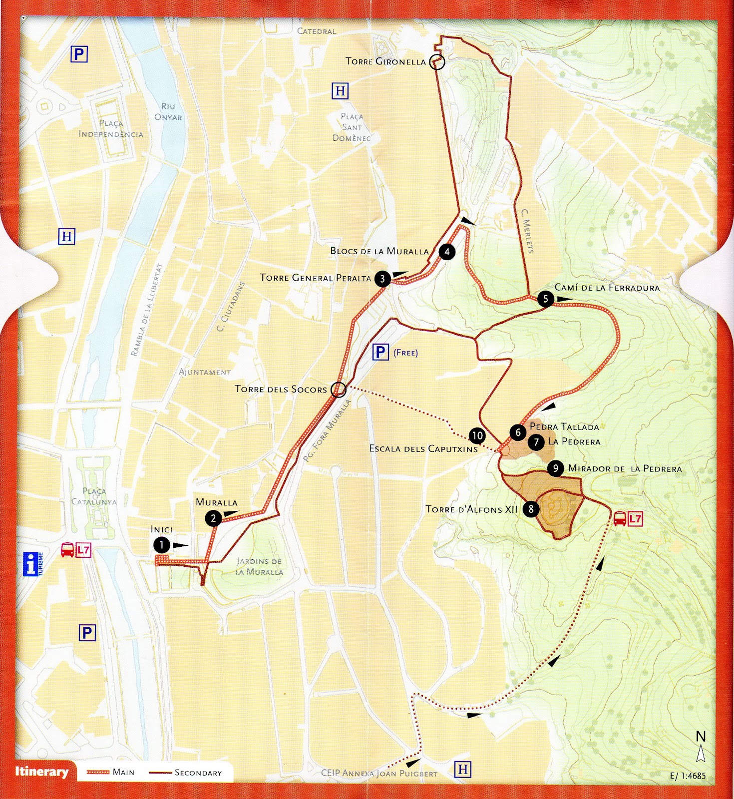
See the link at the bottom of the page to find the original Girona Tourist Office leaflet, available in English. I've put the text here, verbatum, in case you can't get hold of a copy when you arrive, to publicise it and to give an idea of the route. I haven't 'done' it yet, so i can't unreservedly recommend it, but it looks interesting.

This itinerary runs through a district known as Les Pedreres (The Quarries), in the east of the city, beside the Old Town. The name evokes the origin of the district and its function in the history of Girona. The route runs along Camí de la Ferradura, formerly a favourite walking place for Girona inhabitants until the quarries were developed into today’s residential area. On the way, you will learn something about the so-called Girona stone, its composition, and its formation thousands of years ago. The path passes by the old quarries, and demonstrates the widespread use of this stone in the architectural heritage of Girona. It also affords remarkable views over the city. The name Girona stone comes from the fact that it is found in the area surrounding the city and has been quarried here since ancient times. This calcareous sedimentary rock originated from the deposit of 
carbonates and remains of living organisms formed in the shallow tropical sea that covered this area 50 million years ago. The whitish, grey-blue stone contains many fossils of which nummulites are the most frequently found.


From Plaça de Catalunya, climb up to the city wall, and walk along until Torre del General Peralta. Come down from the wall, continue along Passeig de Fora Muralla, turning right towards Camí de la Ferradura, on up to Torre Alfons XII and back down through Les Pedreres district by the Caputxins steps.
Variations: One possible variation is to continue along the city wall until Torre Gironella, then turn into Carrer dels Merlets and Camí de la Ferradura until you reach Torre Alfons XII.Another variation is to start at Joan Puigbert Primary School, go along Carrer del Regiment de Baza, turn to the right up Pujada de la Torre Alfons XII, continue on up to the tower and back down to Torre Gironella via Camí de la Ferradura.

The starting point of the itinerary is Plaça de Catalunya, from where you climb up the steps to the city wall at Jardí de la Infància, site of the former En Banyoles Gate.

1. Starting point
The building of this stretch of the city wall commenced in 1362, following orders from Pere el Cerimoniós, who wished to protect the districts that had sprung up outside the original walled enclosure. The itinerary passes over Les Beates gate and on to a sentry box, along the west side of the former La Mercè bastion (now Jardins de la Muralla). It then passes over Nou gate and Els Socors gate, the latter being of strategic importance as it linked the city to the fortresses at the quarries. The next stop is Torre del General Peralta.

2. City Wall
At the end of Carrer dels Merlets, where it meets Camí de la Ferradura, there is a place to stop and examine some nummulite fossils and, while you are there, enjoy the view over the city. If you look closely at the 
stone, you will see nummulites, i.e., “giant” single-cell organisms protected by a carbonated shell, which used to inhabit the seabed of the shallow waters that covered this area millions of years ago. These are not the only fossils present in the stone; on closer observation, you will also see remains of other organisms, such as ostreids, bivalves, snails, shells and corals. There is a good view of the city from this point, right at the start of 
Camí de la Ferradura. The route continues along this path until it reaches the amphitheatre formed by the walls of the quarry.

3. Torre del General Peralta. 
Panoramic view of the Old Town and the Quarries. At the entrance to the quarry, just where Camí de la Ferradura meets Passeig del General Peralta and Carrer dels Caputxins, you will see some carved stone 
blocks that call to mind the former stone-working trades: quarrymen, stonebreakers, stonecutters, stone carvers, hewers, pavers, porters, bearers etc. These trades, documented from the 14th century onwards, were organised into a system of guilds and brotherhoods, which continued to exist until the liberal reforms of the early 19th century. 

4. City Wall Blocks
Look eastwards from Torre del General Peralta for a good view of the nummulite rock formations in one of the many quarries of the area, source of the stone used for the buildings in the historic city centre. Then 
cast your gaze from north to south to take in the contrast between old, monumental Girona and the more modern urban districts beyond. The old buildings (the walled enclosure, churches such as Sant Feliu, the Cathedral with its wide flight of steps, and most of the surrounding buildings) are striking for the greyish-ochre shades of the Girona stone used in their construction.

5. Camí de la Ferradura. 
Nummulites observation point and view of the city. Close observation of the blocks used to build the city wall shows that calcareous  nummulite rock was the most common building material. We can also see, to a lesser extent, other materials such as plutonic rock, basalt, sandstone 
and fragments of bricks or tiles.

6. Detail of carved stone
At this point, in the semi-circular quarry facing you, you can find a sample of Girona stone carved during the process of extraction. There are also outcrops of lichens, said to be the first stage of colonisation of living organisms, which can be easily observed with the aid of a simple modern plaque. The vegetation on this type of stony soil is mostly dense clumps of Kermes oak; the most frequent trees here are hackberries.

7. Quarry beside camí de la Ferradura
At this point, in the semi-circular quarry facing you, you can find a sample of Girona stone carved during the process of extraction. There are also outcrops of lichens, said to be the first stage of colonisation of living organisms, which can be easily observed with the aid of a simple modern plaque. The vegetation on this type of stony soil is mostly dense clumps of Kermes oak; the most frequent trees here are hackberries

8. Torre Alfons XII
The highest point of the itinerary is Torre Alfons XII, located on a 160 metre high vantage point. The path around its perimeter affords a magnificent panoramic view of the city. This 19th century tower stands on the site of a former stronghold built in 1675 as a watchtower for Condestable fortress, originally part of the east and southeast defence system of Girona. In 1814, French troops blew up the stronghold, along with the other nearby fortresses. Torre Alfons XII was built as a small fort during the Third Carlist War (1872-1876), using the stones from the ruined watchtower, in the style of late 19th-century defence works. Just beneath the tower, you will find the old (disused) Mirador spring, a good place to stop for a rest and contemplate the Old Town from the shade of a hackberry tree.

9. La Pedrera lookout point
A few yards from the tower there is a lookout point affording splendid views of the city, with the Pyrenees on the horizon, among which you can make out the peaks of Canigó and Puig Neulós. You will also be able to observe some natural stone outcrops on the path leading up to the tower.

10. Caputxins steps
The route ends by going down the Caputxins steps and back to the starting point. 

http://www.girona.cat/turisme/eng/docs/ruta_pedra.pdf

Vall de Sant Daniel Walk

From the centre of Girona, head towards the church of Sant Pere de Galligants, off the Plaça de Sant Pere. The little road to the left of the church goes to the valley of Sant Daniel. 
Another route is to find the Gironell Tower of the wall, which is a ruin and looks like blown up grey masonry (which is in fact what it is). 
From here you can walk above and parallel to the previously mentioned road, then you veer off left into olive groves and follow the 'stations of the cross' in a bucolic setting, to arrive at Sant Daniel Monastery. Before visiting the monastery you can walk a while, discovering various 'Fonts' or springs. 
This is where you can find the 'Cul del Mon' restaurant where i sat and had a coffee with ice ('cafe amb gel') on an extremely pleasant, rural terrace. 
If you're not interested in the monastery, you can walk here for supper one evening, earning your first drink on the way, and enjoying the cool of the evening on the way back.
I intend to put more specific directions here, but for now, you have only clues.