This itinerary runs through a district known as Les Pedreres (The Quarries), in the east of the city, beside the Old Town. The name evokes the origin of the district and its function in the history of Girona. The route runs along Camí de la Ferradura, formerly a favourite walking place for Girona inhabitants until the quarries were developed into today’s residential area. On the way, you will learn something about the so-called Girona stone, its composition, and its formation thousands of years ago. The path passes by the old quarries, and demonstrates the widespread use of this stone in the architectural heritage of Girona. It also affords remarkable views over the city. The name Girona stone comes from the fact that it is found in the area surrounding the city and has been quarried here since ancient times. This calcareous sedimentary rock originated from the deposit of
carbonates and remains of living organisms formed in the shallow tropical sea that covered this area 50 million years ago. The whitish, grey-blue stone contains many fossils of which nummulites are the most frequently found.
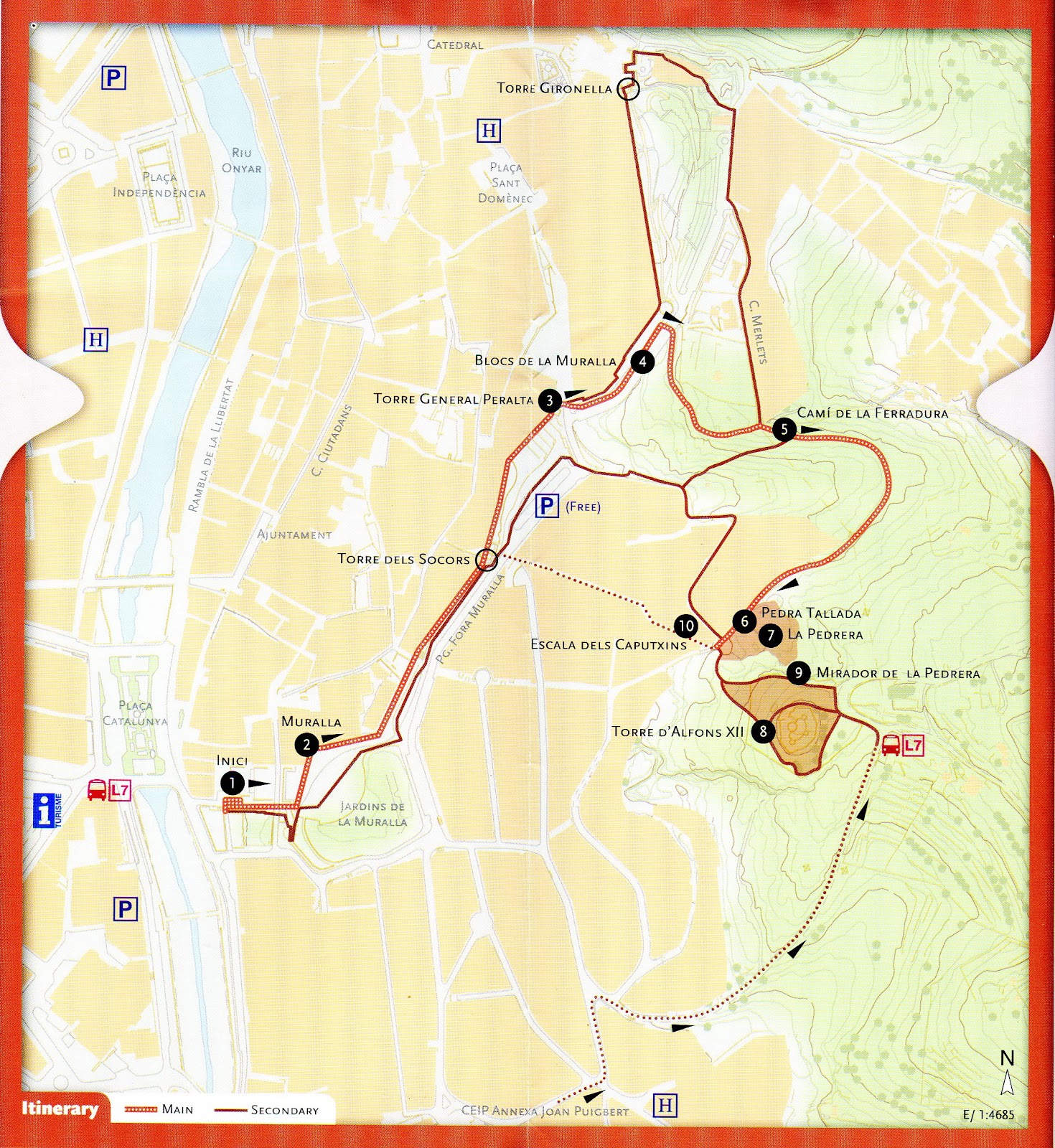
From Plaça de Catalunya, climb up to the city wall, and walk along until Torre del General Peralta. Come down from the wall, continue along Passeig de Fora Muralla, turning right towards Camí de la Ferradura, on up to Torre Alfons XII and back down through Les Pedreres district by the Caputxins steps.
Variations: One possible variation is to continue along the city wall until Torre Gironella, then turn into Carrer dels Merlets and Camí de la Ferradura until you reach Torre Alfons XII.Another variation is to start at Joan Puigbert Primary School, go along Carrer del Regiment de Baza, turn to the right up Pujada de la Torre Alfons XII, continue on up to the tower and back down to Torre Gironella via Camí de la Ferradura.
The starting point of the itinerary is Plaça de Catalunya, from where you climb up the steps to the city wall at Jardí de la Infància, site of the former En Banyoles Gate.
1. Starting point
The building of this stretch of the city wall commenced in 1362, following orders from Pere el Cerimoniós, who wished to protect the districts that had sprung up outside the original walled enclosure. The itinerary passes over Les Beates gate and on to a sentry box, along the west side of the former La Mercè bastion (now Jardins de la Muralla). It then passes over Nou gate and Els Socors gate, the latter being of strategic importance as it linked the city to the fortresses at the quarries. The next stop is Torre del General Peralta.
2. City Wall
At the end of Carrer dels Merlets, where it meets Camí de la Ferradura, there is a place to stop and examine some nummulite fossils and, while you are there, enjoy the view over the city. If you look closely at the
stone, you will see nummulites, i.e., “giant” single-cell organisms protected by a carbonated shell, which used to inhabit the seabed of the shallow waters that covered this area millions of years ago. These are not the only fossils present in the stone; on closer observation, you will also see remains of other organisms, such as ostreids, bivalves, snails, shells and corals. There is a good view of the city from this point, right at the start of
Camí de la Ferradura. The route continues along this path until it reaches the amphitheatre formed by the walls of the quarry.
3. Torre del General Peralta.
Panoramic view of the Old Town and the Quarries. At the entrance to the quarry, just where Camí de la Ferradura meets Passeig del General Peralta and Carrer dels Caputxins, you will see some carved stone
blocks that call to mind the former stone-working trades: quarrymen, stonebreakers, stonecutters, stone carvers, hewers, pavers, porters, bearers etc. These trades, documented from the 14th century onwards, were organised into a system of guilds and brotherhoods, which continued to exist until the liberal reforms of the early 19th century.
4. City Wall Blocks
Look eastwards from Torre del General Peralta for a good view of the nummulite rock formations in one of the many quarries of the area, source of the stone used for the buildings in the historic city centre. Then
cast your gaze from north to south to take in the contrast between old, monumental Girona and the more modern urban districts beyond. The old buildings (the walled enclosure, churches such as Sant Feliu, the Cathedral with its wide flight of steps, and most of the surrounding buildings) are striking for the greyish-ochre shades of the Girona stone used in their construction.
5. Camí de la Ferradura.
Nummulites observation point and view of the city. Close observation of the blocks used to build the city wall shows that calcareous nummulite rock was the most common building material. We can also see, to a lesser extent, other materials such as plutonic rock, basalt, sandstone
and fragments of bricks or tiles.
6. Detail of carved stone
At this point, in the semi-circular quarry facing you, you can find a sample of Girona stone carved during the process of extraction. There are also outcrops of lichens, said to be the first stage of colonisation of living organisms, which can be easily observed with the aid of a simple modern plaque. The vegetation on this type of stony soil is mostly dense clumps of Kermes oak; the most frequent trees here are hackberries.
7. Quarry beside camí de la Ferradura
At this point, in the semi-circular quarry facing you, you can find a sample of Girona stone carved during the process of extraction. There are also outcrops of lichens, said to be the first stage of colonisation of living organisms, which can be easily observed with the aid of a simple modern plaque. The vegetation on this type of stony soil is mostly dense clumps of Kermes oak; the most frequent trees here are hackberries
8. Torre Alfons XII
The highest point of the itinerary is Torre Alfons XII, located on a 160 metre high vantage point. The path around its perimeter affords a magnificent panoramic view of the city. This 19th century tower stands on the site of a former stronghold built in 1675 as a watchtower for Condestable fortress, originally part of the east and southeast defence system of Girona. In 1814, French troops blew up the stronghold, along with the other nearby fortresses. Torre Alfons XII was built as a small fort during the Third Carlist War (1872-1876), using the stones from the ruined watchtower, in the style of late 19th-century defence works. Just beneath the tower, you will find the old (disused) Mirador spring, a good place to stop for a rest and contemplate the Old Town from the shade of a hackberry tree.
9. La Pedrera lookout point
A few yards from the tower there is a lookout point affording splendid views of the city, with the Pyrenees on the horizon, among which you can make out the peaks of Canigó and Puig Neulós. You will also be able to observe some natural stone outcrops on the path leading up to the tower.
10. Caputxins steps
The route ends by going down the Caputxins steps and back to the starting point.
http://www.girona.cat/turisme/eng/docs/ruta_pedra.pdf
No comments:
Post a Comment
Note: only a member of this blog may post a comment.