The appartement made us feel at home in Gerona from the very first moment. Liza received us warmly and recommended some nice spots in the old city. The 4 bedrooms are properly delivered with lining and offer plenty of room for 7 guests. Warm Regards (Holland) (October 2012)
Rosas Routes
These routes and the information is taken from this website http://visit.roses.cat/en
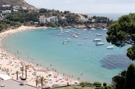 Roses beach is popular with people from the Garrotxa area (Olot) because it is one of the nearest for them and because it is artificial, it is easy to get in and out of the water for those with difficulty moving. It is shallow and many catalans have mentioned to me that they like the sand because it isn't 'dirty'. It's like the eskimo thing about snow - here the quality of the sand affects your beach experience and choice!
Historic Centre of Roses/Rosas
(12th – 20th century)
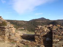 Bufalaranya Castle
(8th-14th centuries) If you like wild places and walking we suggest climbing to Bufalaranya Castle, which was built in the eighth century when the territory of Roses was integrated in the Carolingian Mark. Standing on a hill with difficult access its fortified perimeter has the characteristic of opus spicatum. An air of mystery shrouds the charming remains.
 Seaside route between Almadrava and Cala Montjoi
5 hours (there & back)
The seaside path follows a narrow path at the water’s level between Almadrava beach and Cala Montjoi cove, bordering cliffs and sheer rock faces interspersed with pine groves and typical Mediterranean shrubs. It’s an ideal route for refreshing yourself in any of the coves and beaches along the way, taking a dip in the sea in the summertime. The seaside path begins at the last house on Carrer Gauguin in Almadrava, which is also where the Cap de Creus Natural Park begins.
About 1 km into the route you will reach Punta Falconera (“Falcon’s Point”), so named because of the presence of falcons some years ago. This point was occupied by the military until the 1990s because of its interest as a strategic enclave, as it offers a view that dominates the Bay of Roses. As a result of the military use of the area, there is a network of underground galleries and walkways that are connected to the surface through bunkers with artillery batteries and slits through which the mouths of the artillery pieces once projected.
Past Punta Falconera, the path rises and drops with the sharp coastline, crossing through pine groves and cliffs along the sea, along with a number of well-defined coves. The first of these is Cala Lladó. The quarry, still visible, was used to extract marble, which was then transported by sea to Roses. The ramp and the landing stage where the marble was taken down to the boats at sea level can still be seen today.
After Cap Trencat (literally, “Broken Cape”), which owes its name to the rocks that have broken off over time and fallen into the water, you reach Cala Murtra (a cove where nudism is allowed), named after the Mediterranean myrtle (“murtra” in Catalan), the area’s predominant vegetation. Beyond Cala Murtra lies Cala Rostella, the two coves separated by the Cap Blanc cape.
There are numerous shoals along this section of the coast, dangerous rock formations lurking just below the surface of the water that for centuries had caused shipwrecks. The area is now popular among scuba divers.
Finally, the seaside path reaches the beach at Cala Montjoi. Here, looking towards the end of the valley of the same name, you can distinguish two buildings: Mas de Montjoi de Baix and Mas de Montjoi de Dalt, two farmhouses that gave life to this area in the past.
For those who wish to enjoy the landscape even further, the seaside path continues to wind along the coast. The return route is along the same seaside path to Almadrava beach. Seaside route between Roses lighthouse and Almadrava Beach
Seaside route between Roses lighthouse and Almadrava beach
2 hours 30 minutes (there & back)
The “camins de ronda” (literally, “patrol roads”) owe their name to the traditional patrols bordering the coastline to watch out for smuggling and coastal maritime traffic.
The route follows a section of this seaside path from the Roses lighthouse, which was built during the reign of Isabel II in 1864, located 24 metres above sea level and facing southwards, to the Canyelles Grosses or Almadrava beach.
The lighthouse, which was electrified in 1921 with a 500-watt incandescent lamp, is located just below Trinitat castle, which was recently restored and will be open to visitors.
Throughout the entire route, all the way to Canyelles Petites beach, you can enjoy the unique outcroppings with veined white marble, which are very interesting from a geological perspective.
Right before Canyelles Petites beach there is an islet made up of various rocks, called Els Brancs, which is a resting spot for birds like the cormorant, which can be seen drying off with its wings stretched out and facing the sun.
Continuing along the route past the first beach, the seaside path continues winding along the coast. Between Canyelles and Almadrava beaches, there are two rocky outcroppings that are frequently used by fishermen: Punta de l’Omella and Punta de l’Ullastrell.
Finally, you reach Almadrava beach, whose name comes from the type of fishing with nets strategically placed to drive the fish landward from the end of the cove, until they were finally caught.
You return to the starting point via the same route, but you can take advantage of any of the beaches or rock formations to take a refreshing dip in the sea.
Route through Megalithic History
2 hours 30 minutes
The route starts at the highway from Roses to Montjoi, taking a path with sett paving that leads directly to one of Catalonia’s biggest dolmens, the Creu d’en Cobertella (3000-2700 BC). This dolmen, which features a large gallery grave covered by a stone slab weighing four tons, was declared a historic-artistic monument in 1964.
 Continuing along the path, you pass by a string of dry stone walls that divide the different properties and criss-cross the terraced land in every direction. For hundreds of years, these walls made the task of tending the vines less tedious.
The livestock tracks, which are lined with dry stone walls, cut straight across the land. These tracks were used to move the herds to greener pastures.
At various points you will see – and, in fact, visit – a number of stone sheds that were used by the shepherds for shelter or to store farming tools.
Farther ahead, turn right to reach two more milestones along this megalithic route, the first being the remains of the burnt house, which is the name given to two of the most important menhirs in the area ? the Casa Cremada I and Casa Cremada II menhirs. There is also a kist bearing the same name; like the dolmens, its use was for funerary purposes.
Along the same route you will also visit two well-preserved dolmens: the Llit de la Generala (3200 BC) and the Cap de l’Home dolmens.
On the way back, which will take you to the dolmen where you started, you can enjoy the breathtaking vistas of the Bay of Roses and admire up close the network of walled terraces.
Route between Cap de Creus and the bay of Roses
2 hours 30 minutes
As you go down the highway joining Roses with Cadaqués, take the turn-off to the right that leads to the El Pení air base (E.V.A. 4). Two km from this turn-off, and after having left your vehicle behind in a small embankment used as a car park, take the dirt track that climbs gently up to the Roses wind farm.
A new path branches off to the left some 200 metres after taking the dirt track. Follow this path a few metres to enjoy a magnificent view of Cap Norfeu in all its majesty. The site is catalogued as a natural reserve of the Cap de Creus Natural Park, and it is characterised by a great richness of flora and fauna, both on land and underwater. You will also come across the remains of a cremation site built by Indo-European tribes in the 8th century BC.
Return to the initial track and take it up to Puig Alt, a peak whose surrounding landscape is dominated by the turbines of the Roses wind farm. From this location you can also enjoy one of the site’s most beautiful views: the Bay of Roses on one side, and the Cala Montjoi cove on the other.
The route continues bordering the Puig Alt and then makes a turn of almost 360 degrees to arrive at the Font de la Bich, with a water fountain and a drinking trough for animals. Beyond the fountain, you will discover a magnificent vista of the town of Roses before the path takes you to the crossing of Pla de Can Caussa, in honour of the farmhouse which gives its name to this plain. This is a good spot to stop and rest a bit and have a bite to eat.
From here on, the site you will see is the exact opposite view of the Bay of Roses, namely the northern edge of the Cap de Creus with the waters of the Mar d’Amunt in the background.
A little farther ahead you reach a little hollow with a grove of trees that gives its name to the nearby building: the Mas dels Arbres (literally, the “Trees Farmhouse”).
Finally, you return to the starting point, where you left your vehicle, after having taken a route that has shown you views to the north and south of Cap de Creus, with all its splendorous beauty laid out before your eyes.
Historic Centre of Roses/Rosas
(12th – 20th century)
Stroll along the narrow, uneven, streets in the centre round the church. They all run parallel to the sea and are full of restaurants and small shops where you can enjoy the Mediterranean atmosphere. If you decide to visit Santa Maria Church , you will discover the ancient temple built in 1796 whose apse, transept and dome are still preserved, The rest of the nave, the side chapels and the façade are neo-classical works from 1853 by the architect Martí Sureda I Deulovol. In the Plaça de Catalunya you will find examples of Modernist architecture, like the Casa Mallol, which is the present Town Hall.
 Trinity Castle
Trinity Castle crowns the Poncella point above the lighthouse of Roses. The military construction, which dates from 1544, was erected under the reign of Emperor Charles I, as an essential complement to the Citadel. It has the shape of a five-pointed star, with pronounced angular corners for defence against enemy projectiles. It is built on a grand scale with two-metre thick walls. It had three terraces for batteries of cannons, howitzers and mortars, set at different heights, to defend the port and the coast, It had a garrison of up to two hundred men. The building remains an extraordinary example of coastal artillery fortress.
 Visigothic Fortress
(6th-8th Century) The remains of the mid-seventh-century Visigothic Fortress is one of the most special, hidden and unknown sites in Roses. Although the fortress is located atop a strategic hill overlooking the old town of Rhodes-Roses, the bay and the access to the port, it remains hidden from the sea by Puig Rom. It was inhabited between the seventh and the eighth centuries AD and some archaeological homes, silos and streets still remain today.
Between Trinitat and Escorxadors streets you will find Plaça de la Pau, which is dedicated to the historical memory of the Spanish Civil War. The remodelling of the area, which consists of a sculpture by artist Ció Abellí, was inaugurated in 2006. The sculpture reflects on the irrationality of war and the value of life. In the square there is a bomb shelter built between 1937-1938. It follows the general rules and technical guidelines drafted by the Board of Passive Defence of Catalonia from the period of the republican government.
The Citadel
(4th century BC – 19th century) The walk around the site of La Ciutadella is essential for anyone visiting Roses. Declared a historical and artistic centre in 1961, the citadel contains vestiges of various occupations of the last thirteen centuries. The military fortification, with its monumental Sea Gate, is a Renaissance-style enclosure of 131,480 m² built in 1543. The important archaeological site which lies within the fortification consists of :
(4th century BC – 19th century) The walk around the site of La Ciutadella is essential for anyone visiting Roses. Declared a historical and artistic centre in 1961, the citadel contains vestiges of various occupations of the last thirteen centuries. The military fortification, with its monumental Sea Gate, is a Renaissance-style enclosure of 131,480 m² built in 1543. The important archaeological site which lies within the fortification consists of :
- the remains of the Hellenistic district within the Greek settlement of Rhode, which enjoyed its period of greatest prosperity in the 4th and 3rd century BC
- the Roman villa, dating back to 2nd century BC and 6th century AD.
- the paleochristian necropolis.
- several Visigothic buildings.
- the Lombard Romanesque monastery of Santa Maria, dating back to the 11th century and the remains of the fortified medieval town.
- the remains of several military buildings dating back to 16th century.
- the Museum which provides an insight into the history and heritage of Roses, from prehistory to modern times.
- the Exhibition Hall.
A guided tour of the Citadel is a history master class concentrated in a unique area of seventeen hectares where you can enjoy a complete itinerary, totally signposted including a lot of information.
Trinity Castle crowns the Poncella point above the lighthouse of Roses. The military construction, which dates from 1544, was erected under the reign of Emperor Charles I, as an essential complement to the Citadel. It has the shape of a five-pointed star, with pronounced angular corners for defence against enemy projectiles. It is built on a grand scale with two-metre thick walls. It had three terraces for batteries of cannons, howitzers and mortars, set at different heights, to defend the port and the coast, It had a garrison of up to two hundred men. The building remains an extraordinary example of coastal artillery fortress.
(6th-8th Century) The remains of the mid-seventh-century Visigothic Fortress is one of the most special, hidden and unknown sites in Roses. Although the fortress is located atop a strategic hill overlooking the old town of Rhodes-Roses, the bay and the access to the port, it remains hidden from the sea by Puig Rom. It was inhabited between the seventh and the eighth centuries AD and some archaeological homes, silos and streets still remain today.
(8th-14th centuries) If you like wild places and walking we suggest climbing to Bufalaranya Castle, which was built in the eighth century when the territory of Roses was integrated in the Carolingian Mark. Standing on a hill with difficult access its fortified perimeter has the characteristic of opus spicatum. An air of mystery shrouds the charming remains.
5 hours (there & back)
The seaside path follows a narrow path at the water’s level between Almadrava beach and Cala Montjoi cove, bordering cliffs and sheer rock faces interspersed with pine groves and typical Mediterranean shrubs. It’s an ideal route for refreshing yourself in any of the coves and beaches along the way, taking a dip in the sea in the summertime. The seaside path begins at the last house on Carrer Gauguin in Almadrava, which is also where the Cap de Creus Natural Park begins.
About 1 km into the route you will reach Punta Falconera (“Falcon’s Point”), so named because of the presence of falcons some years ago. This point was occupied by the military until the 1990s because of its interest as a strategic enclave, as it offers a view that dominates the Bay of Roses. As a result of the military use of the area, there is a network of underground galleries and walkways that are connected to the surface through bunkers with artillery batteries and slits through which the mouths of the artillery pieces once projected.
Past Punta Falconera, the path rises and drops with the sharp coastline, crossing through pine groves and cliffs along the sea, along with a number of well-defined coves. The first of these is Cala Lladó. The quarry, still visible, was used to extract marble, which was then transported by sea to Roses. The ramp and the landing stage where the marble was taken down to the boats at sea level can still be seen today.
After Cap Trencat (literally, “Broken Cape”), which owes its name to the rocks that have broken off over time and fallen into the water, you reach Cala Murtra (a cove where nudism is allowed), named after the Mediterranean myrtle (“murtra” in Catalan), the area’s predominant vegetation. Beyond Cala Murtra lies Cala Rostella, the two coves separated by the Cap Blanc cape.
There are numerous shoals along this section of the coast, dangerous rock formations lurking just below the surface of the water that for centuries had caused shipwrecks. The area is now popular among scuba divers.
Finally, the seaside path reaches the beach at Cala Montjoi. Here, looking towards the end of the valley of the same name, you can distinguish two buildings: Mas de Montjoi de Baix and Mas de Montjoi de Dalt, two farmhouses that gave life to this area in the past.
For those who wish to enjoy the landscape even further, the seaside path continues to wind along the coast. The return route is along the same seaside path to Almadrava beach. Seaside route between Roses lighthouse and Almadrava Beach
Seaside route between Roses lighthouse and Almadrava beach
2 hours 30 minutes (there & back)
The “camins de ronda” (literally, “patrol roads”) owe their name to the traditional patrols bordering the coastline to watch out for smuggling and coastal maritime traffic.
The route follows a section of this seaside path from the Roses lighthouse, which was built during the reign of Isabel II in 1864, located 24 metres above sea level and facing southwards, to the Canyelles Grosses or Almadrava beach.
The lighthouse, which was electrified in 1921 with a 500-watt incandescent lamp, is located just below Trinitat castle, which was recently restored and will be open to visitors.
Throughout the entire route, all the way to Canyelles Petites beach, you can enjoy the unique outcroppings with veined white marble, which are very interesting from a geological perspective.
Right before Canyelles Petites beach there is an islet made up of various rocks, called Els Brancs, which is a resting spot for birds like the cormorant, which can be seen drying off with its wings stretched out and facing the sun.
Continuing along the route past the first beach, the seaside path continues winding along the coast. Between Canyelles and Almadrava beaches, there are two rocky outcroppings that are frequently used by fishermen: Punta de l’Omella and Punta de l’Ullastrell.
Finally, you reach Almadrava beach, whose name comes from the type of fishing with nets strategically placed to drive the fish landward from the end of the cove, until they were finally caught.
You return to the starting point via the same route, but you can take advantage of any of the beaches or rock formations to take a refreshing dip in the sea.
Route through Megalithic History
2 hours 30 minutes
The route starts at the highway from Roses to Montjoi, taking a path with sett paving that leads directly to one of Catalonia’s biggest dolmens, the Creu d’en Cobertella (3000-2700 BC). This dolmen, which features a large gallery grave covered by a stone slab weighing four tons, was declared a historic-artistic monument in 1964.
The livestock tracks, which are lined with dry stone walls, cut straight across the land. These tracks were used to move the herds to greener pastures.
At various points you will see – and, in fact, visit – a number of stone sheds that were used by the shepherds for shelter or to store farming tools.
Farther ahead, turn right to reach two more milestones along this megalithic route, the first being the remains of the burnt house, which is the name given to two of the most important menhirs in the area ? the Casa Cremada I and Casa Cremada II menhirs. There is also a kist bearing the same name; like the dolmens, its use was for funerary purposes.
Along the same route you will also visit two well-preserved dolmens: the Llit de la Generala (3200 BC) and the Cap de l’Home dolmens.
On the way back, which will take you to the dolmen where you started, you can enjoy the breathtaking vistas of the Bay of Roses and admire up close the network of walled terraces.
Route between Cap de Creus and the bay of Roses
2 hours 30 minutes
As you go down the highway joining Roses with Cadaqués, take the turn-off to the right that leads to the El Pení air base (E.V.A. 4). Two km from this turn-off, and after having left your vehicle behind in a small embankment used as a car park, take the dirt track that climbs gently up to the Roses wind farm.
A new path branches off to the left some 200 metres after taking the dirt track. Follow this path a few metres to enjoy a magnificent view of Cap Norfeu in all its majesty. The site is catalogued as a natural reserve of the Cap de Creus Natural Park, and it is characterised by a great richness of flora and fauna, both on land and underwater. You will also come across the remains of a cremation site built by Indo-European tribes in the 8th century BC.
Return to the initial track and take it up to Puig Alt, a peak whose surrounding landscape is dominated by the turbines of the Roses wind farm. From this location you can also enjoy one of the site’s most beautiful views: the Bay of Roses on one side, and the Cala Montjoi cove on the other.
The route continues bordering the Puig Alt and then makes a turn of almost 360 degrees to arrive at the Font de la Bich, with a water fountain and a drinking trough for animals. Beyond the fountain, you will discover a magnificent vista of the town of Roses before the path takes you to the crossing of Pla de Can Caussa, in honour of the farmhouse which gives its name to this plain. This is a good spot to stop and rest a bit and have a bite to eat.
From here on, the site you will see is the exact opposite view of the Bay of Roses, namely the northern edge of the Cap de Creus with the waters of the Mar d’Amunt in the background.
A little farther ahead you reach a little hollow with a grove of trees that gives its name to the nearby building: the Mas dels Arbres (literally, the “Trees Farmhouse”).
Finally, you return to the starting point, where you left your vehicle, after having taken a route that has shown you views to the north and south of Cap de Creus, with all its splendorous beauty laid out before your eyes.
sent by email review Gironalet apartment
We arrived by train (2 minutes from the apartment!) and then hired a car to do some longer day trips from Girona, although we could’ve got the bus. The train to Barcelona is only an hour. The apartment is impeccably clean, quiet, spacious and of really good quality. Lovely crisp sheets and new beds!. There are lots of restaurants nearby but we cooked in the apartment quite often – there’s a great little supermarket around the corner. The website doesn’t mention the terrace, but for hanging out in the evening or afternoon it’s good to have some outside space and really comfortable, though small. In the morning it’s usually too sunny. We had a great time in Girona, thankyou Liza! (UK) (September 2012)
Girona Museums
Museum of Cinema
See 'Original Version Cinema' post in 'Days Out' section for more.
City of Girona History Museum
The aim of Girona City History Museum is to show the evolution of the city, starting with the first human remains found in the area and continuing right up to the transition to democracy after the Franco dictatorship, and to portray the society that brought it all about. The fourteen exhibition rooms, arranged in chronological order, are complemented by theme rooms such as those dedicated to industrial Girona/pioneer city, sardana dancing and cobla bands, and contemporary Girona. It's more interesting than it sounds! The website is also very clear, informative on Catalan history and in English!
See 'Original Version Cinema' post in 'Days Out' section for more.
From Chinese shadows to the Lumière brother's camera, there are many fascinating and amusing inventions that you can now see in Girona at the Museum of the Cinema. One of the Europe's most important collections and a visit recommended for everyone and all ages.http://www.museudelcinema.cat/cat/museu_missio.php
City of Girona History Museum
The aim of Girona City History Museum is to show the evolution of the city, starting with the first human remains found in the area and continuing right up to the transition to democracy after the Franco dictatorship, and to portray the society that brought it all about. The fourteen exhibition rooms, arranged in chronological order, are complemented by theme rooms such as those dedicated to industrial Girona/pioneer city, sardana dancing and cobla bands, and contemporary Girona. It's more interesting than it sounds! The website is also very clear, informative on Catalan history and in English!
http://www.girona.cat/museuciutat/eng/museu_presentacio.php
Jewish History Museum of Girona
The Museum's eleven galleries form an itinerary allowing visitors to learn about aspects of the everyday life, culture and history of the Jewish communities of Catalonia and of Girona during medieval times. It is housed on the site of the 3rd medieval Synagogue of Girona. The website also has lots of information on the different sections of the musuem. An enjoyable visit when you go to visit the 'call' or Jewish quarter of Girona.
http://www.girona.cat/call/eng/index.php
.JPG)
Art Museum of Girona
A very pleasant, quiet place to visit, starting with pre-romanesque art pieces found mostly in the surrounding areas, going through the centuries up to the 20th and with explanations in each room of the pieces and the period, in English. http://www.museuart.com/eng/index.html
Museum- Treasure of the Cathedral
Collections of religious art showing liturgical art of the cathedral through its history. The most famous piece is the Tapestry of Creation - the cathedral audio-guide is worthwhile.
Jewish History Museum of Girona
The Museum's eleven galleries form an itinerary allowing visitors to learn about aspects of the everyday life, culture and history of the Jewish communities of Catalonia and of Girona during medieval times. It is housed on the site of the 3rd medieval Synagogue of Girona. The website also has lots of information on the different sections of the musuem. An enjoyable visit when you go to visit the 'call' or Jewish quarter of Girona.
| COMMUNITY LIFE | FESTIVALS & TRADITIONS | THE LIFE CYCLE | THE JEWRIES |
| THE DIASPORA | THE SYNAGOGUE | THE CEMETERY | THE CULTURAL HERITAGE |
| DAILY BREAD | CULTURAL CO-EXISTENCE | JEWISH CONVERTS AND THE INQUISITION | |
.JPG)
Art Museum of Girona
A very pleasant, quiet place to visit, starting with pre-romanesque art pieces found mostly in the surrounding areas, going through the centuries up to the 20th and with explanations in each room of the pieces and the period, in English. http://www.museuart.com/eng/index.html
Museum- Treasure of the Cathedral
Collections of religious art showing liturgical art of the cathedral through its history. The most famous piece is the Tapestry of Creation - the cathedral audio-guide is worthwhile.
The Stone of Girona Route
See the link at the bottom of the page to find the original Girona Tourist Office leaflet, available in English. I've put the text here, verbatum, in case you can't get hold of a copy when you arrive, to publicise it and to give an idea of the route. I haven't 'done' it yet, so i can't unreservedly recommend it, but it looks interesting.
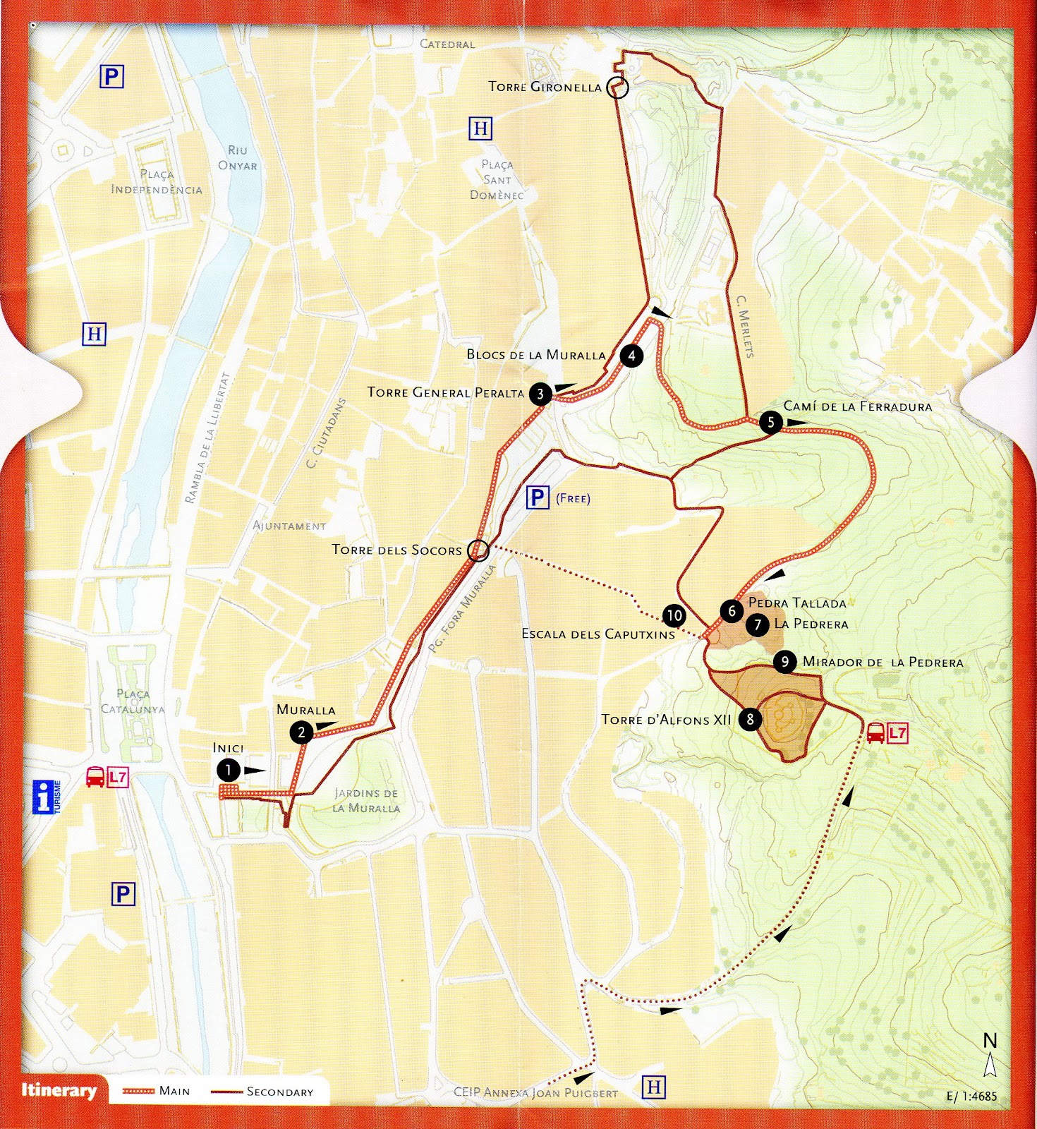
This itinerary runs through a district known as Les Pedreres (The Quarries), in the east of the city, beside the Old Town. The name evokes the origin of the district and its function in the history of Girona. The route runs along Camí de la Ferradura, formerly a favourite walking place for Girona inhabitants until the quarries were developed into today’s residential area. On the way, you will learn something about the so-called Girona stone, its composition, and its formation thousands of years ago. The path passes by the old quarries, and demonstrates the widespread use of this stone in the architectural heritage of Girona. It also affords remarkable views over the city. The name Girona stone comes from the fact that it is found in the area surrounding the city and has been quarried here since ancient times. This calcareous sedimentary rock originated from the deposit of
carbonates and remains of living organisms formed in the shallow tropical sea that covered this area 50 million years ago. The whitish, grey-blue stone contains many fossils of which nummulites are the most frequently found.
From Plaça de Catalunya, climb up to the city wall, and walk along until Torre del General Peralta. Come down from the wall, continue along Passeig de Fora Muralla, turning right towards Camí de la Ferradura, on up to Torre Alfons XII and back down through Les Pedreres district by the Caputxins steps.
Variations: One possible variation is to continue along the city wall until Torre Gironella, then turn into Carrer dels Merlets and Camí de la Ferradura until you reach Torre Alfons XII.Another variation is to start at Joan Puigbert Primary School, go along Carrer del Regiment de Baza, turn to the right up Pujada de la Torre Alfons XII, continue on up to the tower and back down to Torre Gironella via Camí de la Ferradura.
The starting point of the itinerary is Plaça de Catalunya, from where you climb up the steps to the city wall at Jardí de la Infància, site of the former En Banyoles Gate.
1. Starting point
The building of this stretch of the city wall commenced in 1362, following orders from Pere el Cerimoniós, who wished to protect the districts that had sprung up outside the original walled enclosure. The itinerary passes over Les Beates gate and on to a sentry box, along the west side of the former La Mercè bastion (now Jardins de la Muralla). It then passes over Nou gate and Els Socors gate, the latter being of strategic importance as it linked the city to the fortresses at the quarries. The next stop is Torre del General Peralta.
2. City Wall
At the end of Carrer dels Merlets, where it meets Camí de la Ferradura, there is a place to stop and examine some nummulite fossils and, while you are there, enjoy the view over the city. If you look closely at the
stone, you will see nummulites, i.e., “giant” single-cell organisms protected by a carbonated shell, which used to inhabit the seabed of the shallow waters that covered this area millions of years ago. These are not the only fossils present in the stone; on closer observation, you will also see remains of other organisms, such as ostreids, bivalves, snails, shells and corals. There is a good view of the city from this point, right at the start of
Camí de la Ferradura. The route continues along this path until it reaches the amphitheatre formed by the walls of the quarry.
3. Torre del General Peralta.
Panoramic view of the Old Town and the Quarries. At the entrance to the quarry, just where Camí de la Ferradura meets Passeig del General Peralta and Carrer dels Caputxins, you will see some carved stone
blocks that call to mind the former stone-working trades: quarrymen, stonebreakers, stonecutters, stone carvers, hewers, pavers, porters, bearers etc. These trades, documented from the 14th century onwards, were organised into a system of guilds and brotherhoods, which continued to exist until the liberal reforms of the early 19th century.
4. City Wall Blocks
Look eastwards from Torre del General Peralta for a good view of the nummulite rock formations in one of the many quarries of the area, source of the stone used for the buildings in the historic city centre. Then
cast your gaze from north to south to take in the contrast between old, monumental Girona and the more modern urban districts beyond. The old buildings (the walled enclosure, churches such as Sant Feliu, the Cathedral with its wide flight of steps, and most of the surrounding buildings) are striking for the greyish-ochre shades of the Girona stone used in their construction.
5. Camí de la Ferradura.
Nummulites observation point and view of the city. Close observation of the blocks used to build the city wall shows that calcareous nummulite rock was the most common building material. We can also see, to a lesser extent, other materials such as plutonic rock, basalt, sandstone
and fragments of bricks or tiles.
6. Detail of carved stone
At this point, in the semi-circular quarry facing you, you can find a sample of Girona stone carved during the process of extraction. There are also outcrops of lichens, said to be the first stage of colonisation of living organisms, which can be easily observed with the aid of a simple modern plaque. The vegetation on this type of stony soil is mostly dense clumps of Kermes oak; the most frequent trees here are hackberries.
7. Quarry beside camí de la Ferradura
At this point, in the semi-circular quarry facing you, you can find a sample of Girona stone carved during the process of extraction. There are also outcrops of lichens, said to be the first stage of colonisation of living organisms, which can be easily observed with the aid of a simple modern plaque. The vegetation on this type of stony soil is mostly dense clumps of Kermes oak; the most frequent trees here are hackberries
8. Torre Alfons XII
The highest point of the itinerary is Torre Alfons XII, located on a 160 metre high vantage point. The path around its perimeter affords a magnificent panoramic view of the city. This 19th century tower stands on the site of a former stronghold built in 1675 as a watchtower for Condestable fortress, originally part of the east and southeast defence system of Girona. In 1814, French troops blew up the stronghold, along with the other nearby fortresses. Torre Alfons XII was built as a small fort during the Third Carlist War (1872-1876), using the stones from the ruined watchtower, in the style of late 19th-century defence works. Just beneath the tower, you will find the old (disused) Mirador spring, a good place to stop for a rest and contemplate the Old Town from the shade of a hackberry tree.
9. La Pedrera lookout point
A few yards from the tower there is a lookout point affording splendid views of the city, with the Pyrenees on the horizon, among which you can make out the peaks of Canigó and Puig Neulós. You will also be able to observe some natural stone outcrops on the path leading up to the tower.
10. Caputxins steps
The route ends by going down the Caputxins steps and back to the starting point.
http://www.girona.cat/turisme/eng/docs/ruta_pedra.pdf
Vall de Sant Daniel Walk
From the centre of Girona, head towards the church of Sant Pere de Galligants, off the Plaça de Sant Pere. The little road to the left of the church goes to the valley of Sant Daniel.
Another route is to find the Gironell Tower of the wall, which is a ruin and looks like blown up grey masonry (which is in fact what it is).
From here you can walk above and parallel to the previously mentioned road, then you veer off left into olive groves and follow the 'stations of the cross' in a bucolic setting, to arrive at Sant Daniel Monastery. Before visiting the monastery you can walk a while, discovering various 'Fonts' or springs.
This is where you can find the 'Cul del Mon' restaurant where i sat and had a coffee with ice ('cafe amb gel') on an extremely pleasant, rural terrace.
If you're not interested in the monastery, you can walk here for supper one evening, earning your first drink on the way, and enjoying the cool of the evening on the way back.
I intend to put more specific directions here, but for now, you have only clues.

Apartment gironalet
This apartment is fantastic to a family or adults that want to visit Girona. all is there, with high standard Liza well come us vey nice . we got much help from here in English..... parking ( pablic) is at the house for resonable fee, the apartment is only 15 Min walk from the hard of toen dont hasitate to use this place when you are in girona, even elevator will help you to the house all was easy clean and nice we enjoied it very much (Israel) (October 2012)
Families - Gironalet Apartment
We are family of 6. The apartment was perfect for us, with plenty of rooms for the kids to spread around in. The provided entertainment (DVD, board games) were also very enjoyable. Kitchen facilities were extremely handy and we very much appreciated that some condiments were provided, making it easy and efficient to cook some quick meals.
The location of the apartment is excellent. Very close to the historic city center and walking distance to shops, supermarkets and restaurants. The carpark right by the building also was very convenient, as we were traveling with a van.
I would highly recommend this apartment for any family with children.
(Israel) (May 2012)
Can Manolo
In 1958, on August 8th, Dali married Gala in the Sanctuary at the top of Els Angels mountain. They had their reception in La Barca restaurant, now known as Can Manolo. They had assorted cold meats and patés to start, followed by seafood and chicken - the food of the rich in those times. It is still famed for its' extensive menu and traditional catalan and spanish fare. Their specialities are suckling pig and very young lamb from Burgos. They do all types of grilled meat and also fish and the dishes are huge.They haven't gone over board with the website but it gives you an idea of what
to expect.

http://www.canmanolo.com/
We tried to go during the 'Fires' or fiestas of Sant Narcis, patron saint of Girona. Full up! And that with a slight walk involved! So we booked for the evening and were rewarded with the most amazingly attractive tuna and tomato salad (i mean, i wasn't expecting all that from a tuna salad, but try it and you'll want to paint it), followed by filet steaks. Desserts are satisfying though not original, the atmosphere is great. We were n't quite up to the suckling pig. We had a Figuero wine, (not oaked) recommended by the house, not exorbitant, very enjoyable. The service was extremely kind and efficient.
to expect.
http://www.canmanolo.com/
We tried to go during the 'Fires' or fiestas of Sant Narcis, patron saint of Girona. Full up! And that with a slight walk involved! So we booked for the evening and were rewarded with the most amazingly attractive tuna and tomato salad (i mean, i wasn't expecting all that from a tuna salad, but try it and you'll want to paint it), followed by filet steaks. Desserts are satisfying though not original, the atmosphere is great. We were n't quite up to the suckling pig. We had a Figuero wine, (not oaked) recommended by the house, not exorbitant, very enjoyable. The service was extremely kind and efficient.
Short cycle-tourism routes from Girona
This website has some good ideas for cycling from Girona with GPS tracks and explanations. It is in English. They are short cyclo-tourism routes. Just be careful with the routes that go on 'tracks' as these are no good for road bikes - if you take a good map you'll find an alternative. Here is an example:
THE ADAC’S CYCLOTOURISM ROUTES |
Nº 11
GIRONA - L'ESTARTIT
|
Girona – Sarrià de Ter – El Pont Major – Celrà – Sant Joan de Mollet – Flaçà – Sant Llorenç de les Arenes – Foixà – La Sala – Ultramort – Serra de Darò – Gualta – Torroella de Montgrí – L’Estartit |
| Description of the cycling route: The cycling route that we propose from Girona to L’Estartit is quite different from the routes that we know as Greenways in our area (the ones from Girona to Olot and from Girona to Sant Feliu de Guíxols which follow the paths of the former railway line). These are real cycling routes that you can follow with no risk of getting lost and where you will only find cyclists and no other vehicles. Our route is composed by rural paths and tracks that can be linked to arrive at L’Estartit. There are no signposts! So that you will need a certain experience using maps and finding ways. A satnav can help you. The aventure starts! As we said for the route from L’Estartit to Girona, the main attraction of this route is that it allows you to make quite a long journey using no main roads and finding no cars, cycling through landscapes and villages which can be quite interesting from a cultural point of view. The route follows rural tracks, the quietest, the most direct and the most interesting that we have found. When you leave Girona, to avoid the traffic, you will follow a very funny path which starts at the sportscenter called Poliesportiu de Fontajau and ends at the dual carriageway of Sarrià de Ter near the furniture shop called Mobles Balti. We go on the pavement until we reach the so-called Pont Major (Main Bridge). From Pont Major to the next village of Celrà we will have to follow the main road which is always quite busy, however, as soon as we reach the industrial area of Celrà we will finally start cycling again on quiet tracks until the end of the route. In the road-book you will find more information to follow the route. See also the route l'Estartit - Girona Happy cycling! Narcís |
| . | |
| . |
KM
| ACCUMULATED CLIMB M | RECOMMENDED US GPS | TYPE OF WAY | ||||
| ROAD | SECONDARY ROADS | CYCLEWAY | TRACK | PATH | |||
47
| 184 | ||||||
| . |
| .plt/zip | word/zip | |
| . |
 |
Sant Pere de Rodes Monastery Day Out 7

The History of Catalonia Museum, has this guide to the monastery.
http://www.mhcat.net/content/download/9335/71903/file/Monestir+St.Pere+Rodes+guide+of+visit+angles%5B1%5D.pdf
And this is the museum link but it only seems to open in catalan
http://www.es.mhcat.cat/content/view/full/6050
Calella de Palafrugell


Calella - Cap Roig Gardens, heading south, takes about an hour. You can walk to the beach at Castell, passing other beaches and Iberian settlements nestled among the pines. To Castell takes about 2 hours and a bit going leisurely.


Famous for the singing of 'Havaneres' in July, when you definitely won't find a spare rock to sit on. This blogsite has some lovely music, postcards and photos of Calella.
http://calelladepalafrugellileshavaneres.blogspot.com.es/
At the same time as listening to them, you should be burning rum on the beach (alas, no space).

Here's a look at the festival of music and dance in summer, held at the Cap Roig Gardens
http://www.caproigfestival.com/en/
Here is information about visiting the gardens
http://obrasocial.lacaixa.es/StaticFiles/StaticFiles/8408c7f863741310VgnVCM200000128cf10aRCRD/es/los_jardines_de_cap_roig_es.pdf
Subscribe to:
Comments (Atom)